Kinshasa flood disaster highlights deadly mix of rapid urban growth and poor infrastructure
Of Kinshasa’s two flood risks, the impact of Congo River flooding can be observed in large cities located along major rivers, and typically peaks around January.
Gode Bola, University of Kinshasa ; Mark Trigg, University of Leeds, and Raphaël Tshimanga, University of Kinshasa
More To Read
- France jails former Congolese rebel leader Roger Lumbala for war crimes
- AFC/M23 rebels announce withdrawal from Uvira, citing progress in Doha framework
- In eastern DR Congo's Uvira, war scars linger as calm cautiously returns
- Peace falters as fighting in eastern DR Congo raises fears of regional war
- Burundi closes border with DR Congo after M23 enters Uvira, sources say
- UN warns human rights face growing threats worldwide in 2025 as funding for activists falls
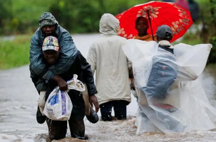
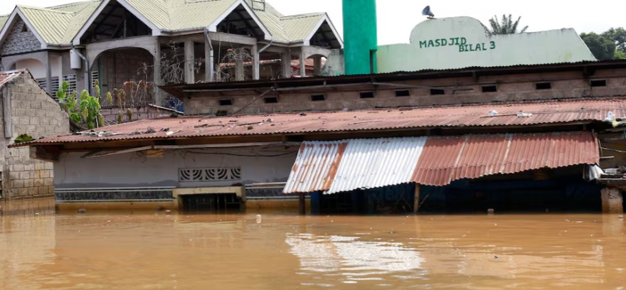
The April 2025 flooding disaster in Kinshasa, the capital of the Democratic Republic of Congo, wasn’t just about intense rainfall. It was a symptom of recent land use change, which has occurred rapidly in the city, turning it into a sprawling urban settlement without the necessary drainage infrastructure.
Local rains combined with runoff from torrential rains coming from neighbouring Congo Central Province quickly overwhelmed the city’s small urban tributaries. The Ndjili River and its tributary (Lukaya), which run through the city, overflowed and flooded homes on either side.
This led to the deaths of at least 70 people, 150 injured and the temporary displacement of more than 21,000 people. Floods affected the running of 73 healthcare facilities. Access to water and transport services was disrupted in large parts of the city. People could only move around by dugout canoe or by swimming in flooded avenues.
Floods have become recurrent in the DRC. The last quarter of 2023 and the beginning of 2024 saw the most devastating floods there and in neighbouring countries since the 1960s.
According to UN World Urbanisation Prospects (2025), the reason the floods have become this devastating is the growth of Kinshasa. The city is the most densely populated city in the DRC, the most populous city and the third-largest metropolitan area in Africa.
Kinshasa’s 2025 population is estimated at 17,778,500. Back in 1950, it was 201,905. In the past year alone, the city’s population has grown by 746,200, a 4.38% annual change. At least 2% of the population lives in areas prone to flooding. Urban infrastructure, especially flood-related, is non-existent or inadequate. Where it exists, drainage systems are blocked by solid waste, itself another sign of the city whose public services, such as waste collection, have become dysfunctional.
We have been studying the characteristics of flooding and the prediction of risk linked to it in the Congo Basin for five years as part of our work at the Congo Basin Water Resources Research Centre in Kinshasa. We study the movement of water in natural and modified environments and its interactions with infrastructure over a range of geographical scales. We argue in this article that understanding why Kinshasa floods means recognising two very different water systems at play – and how urban growth has made the city more vulnerable to both.
Kinshasa faces two distinct flood hazards: first, flooding from the Congo River, which typically peaks around December and January; and, second, urban flood events driven by local rainfall and runoff from the hills south of the city around April and December.
Most of Kinshasa’s flood disasters have come from the second type. As Kinshasa has urbanised, expanding into the floodplains, but without the necessary urban infrastructure, the impact of urban flood events has become worse.
With more sealed surfaces – because of more urban settlements – and less natural water absorption, more rainwater runs off and faster. This overwhelms the city’s small urban tributaries and the River Ndjili.
Growth of Kinshasa and flood
As the city has expanded, so has its flood exposure. The city’s tributaries drain steep, densely populated urban slopes and are highly responsive to rainfall.
Of Kinshasa’s two flood risks, the impact of Congo River flooding can be observed in large cities located along major rivers, and typically peaks around January. These are seasonal floods driven by rainfall across the whole Congo Basin.
Research at the Congo Basin Water Resources Research Centre shows that while Congo River high water levels can cause “backwater effects” – the upstream rise in water level caused by reduced flow downstream – most damaging floods result from intense local rainfall overwhelming the city’s small river catchments. The flood risk analysis indicates that 38 territories are the hotspots of flooding in the Congo basin. Kinshasa is a hotspot due to its double risk sources and extensive urbanisation.
Other Topics To Read
- Democratic Republic of Congo
- Kinshasa
- DRC
- Waste management
- infrastructure
- Democratic Republic of the Congo
- rain
- Kinshasa Floods
- DRC floods
- Urbanisation
- Cities
- Rivers
- Land use
- Town planning
- Congo basin
- Kinshasa flood disaster highlights deadly mix of rapid urban growth and poor infrastructure
- Headlines
The urban flood events are more challenging. They can happen with less rainfall and cause major destruction. They are driven by local rainfall and the rapid growth of informal settlements.
Other cities face similar risks. In 2024, Nairobi suffered deadly floods after prolonged rain overwhelmed informal neighbourhoods and infrastructure.
Across Africa, cities are growing faster than their infrastructure can keep up with. Kinshasa has unique exposure, but also strong local research capacity.
The Congo River’s seasonal peaks are relatively well understood and monitored. But urban tributaries are harder to predict.
DRC’s meteorological agency, Mettelsat and its partners are building capacity for real-time monitoring. But the April 2025 floods showed that community-level warning systems did not work.
Climate change is expected to intensify extreme rainfall in central Africa. While annual totals may not increase, short, intense storms could become more frequent.
This increases pressure on cities already struggling with today’s rains. In Kinshasa, the case for climate-resilient planning and infrastructure is urgent.
What needs to change?
Forecasting rainfall is not enough. Government agencies in collaboration with universities must also forecast flood impact, and ensure people can act on the warnings. There is a need to put in place systems to achieve this under a catchment-integrated flood management plan.
The main elements of such a plan include:
- Improved early warning systems: Use advanced technologies (such as satellites) to gather real-time data on environmental conditions.
- Upgraded drainage infrastructure: Identify weaknesses and areas prone to flooding, to manage stormwater better.
- Enforcement of land use planning: Establish clear regulations that define flood-prone areas; outline permissible land uses.
- Define safety perimeters around areas at risk of flooding: Use historical data, flood maps, and hydrological studies to pinpoint areas that are at risk. Regulate development and activities there.
- Local engagement in flood preparedness: Educate residents about flood risks, preparedness measures, and emergency response.
The Conversation
Gode Bola, Lecturer in Hydrology, University of Kinshasa; Mark Trigg, Professor of Water Risk, University of Leeds, and Raphaël Tshimanga, Director of the Regional School of Water and the Congo Basin Water Resources Research Centre (CRREBaC), University of Kinshasa
This article is republished from The Conversation under a Creative Commons license. Read the original article.
Top Stories Today